About MoFuSS Course

Modeling fuelewood enviromental impacts with MoFuSS V1.0

#


PROGRAMME

You are invited to a one-day course to learn about quantifying carbon savings from fuelwood reduction interventions using the freeware MoFuSS. The course will be given in English on September 3rd and in French on September 4th; between 08:30 and 17:00.

Course Description:
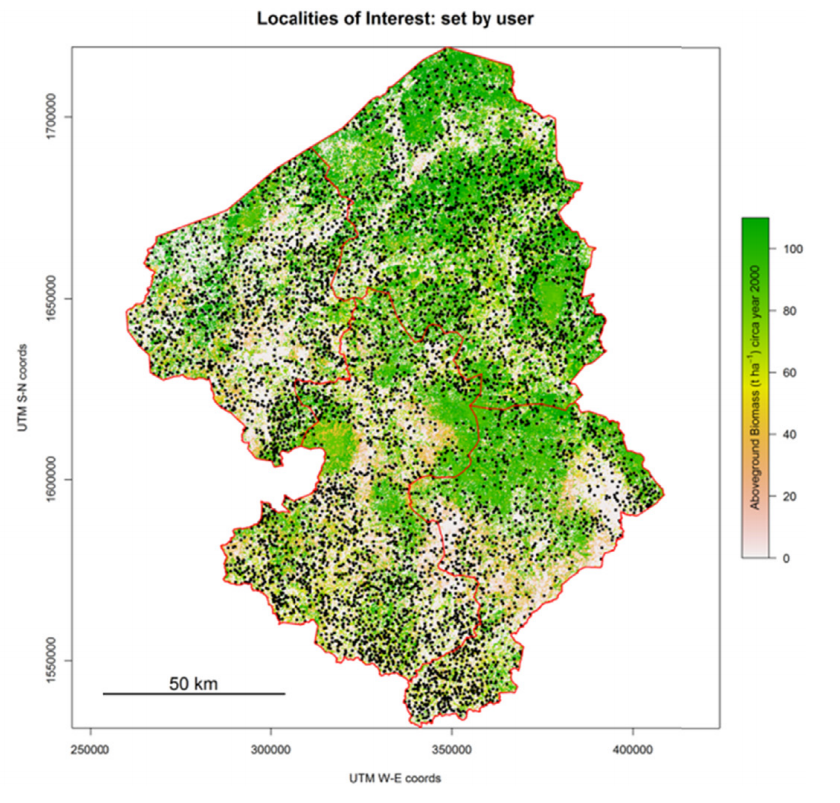
The training course is based on a modeling tool called MoFuSS (Modeling Fuelwood Savings Scenarios). MoFuSS was designed to assess fuelwood-driven degradation in a variety of contexts. In short, the tool is a landscape-level computer model that simulates fuelwood harvesting in space and time, and expected regrowth of the vegetation. By means of what-if scenarios embedded within dynamic landscapes, MoFuSS can be used to account for savings in non-renewable woody biomass from reduced fuelwood consumption. Practical exercises will be conducted using datasets from Mexico and Central America, Kenya and India. MoFuSS was developed during one of the Global Alliance for Clean Cookstoves (GACC) projects between 2013-2015: Geospatial Analysis and Modeling of Non-Renewable Biomass: WISDOM and beyond. It was built for GACC partners and other stakeholders to assess fuelwood-driven degradation in a variety of contexts.

Objective:
Train up to 70 people (35 each day) in fuelwood modeling techniques using available data and freeware. The underlying objectives of simulations are 1) to better understand where and when fuelwood could be a driver of forests and woodland degradation in terms of aboveground biomass density and 2) serve as a decision making tool, informing local policy makers and practitioners working in the field.

Target audience:
Anyone interested or in the need to quantify carbon savings from fuelwood reduction interventions (e.g. clean cookstoves, fuel switching, etc.). No GIS or programming skills are needed when running the model using provided default datasets.

Registration and fees:
Register using the online form. In case of overbooking, participants will be selected by their registration date. The course has no cost for everybody.

Outputs and Expectations:
MoFuSS has six different levels of interaction with end-users according to their expertise with spatial analysis and modeling software and techniques. The main expectation of this course is that attendants manage to build scenarios with MoFuSS for any of the provided datasets by means of a user-friendly interfase (up to Level 3).

Modeling Tool

MoFuSS V1.0

#

MoFuSS: Modeling Fuelwood Savings Scenarios is a GIS-based open-source freeware developed to evaluate potential impacts of residential firewood use over the landscape. Users have different levels of interaction, from querying available results in a mapserver to uploading their own maps and parameters and ultimately affect underlying geoprocessing operations. MoFuSS is developed and supported by the Environmental Geography Research Center (CIGA) at the National Autonomous University of Mexico (UNAM), in collaboration with the US Center of the Stockholm Environment Institute. The first version of MoFuSS (version 1.0) was developed between September 2011 and April 2015 with funding from Global Alliance for Clean CookstovesYale Institute for Biospheric StudiesOverlook International FoundationClimateWorks and UNAM’s PAPIIT.
We developed MoFuSS with the underlying objective of producing estimates of non-renewable biomass (NRB) at landscape level while allowing users to input the best available data for their area of interest, including project-specific maps and parameters. MoFuSS was developed thinking in a wide range of users from academics and practitioners, to students and NGOs. Used correctly, it should help these stakeholders to: a) get more consistent estimates of fuelwood-related carbon savings within their interest areas, and b) plan sound and cost-effective intervention projects. MoFuSS consists of several “scripts” or list of commands that are executed by freely available computer programs and packages (e.g. DINAMICA EGO, R, FFmpeg, LaTeX, GoogleEarth). Before the course, all scripts will be available for download along with training datasets for Mexico, Central America, Kenya and India (Karnataka). Training datasets vary in size depending on the region and are comprised of spatial raster and vector data and other non-spatial tabular datasets.
MoFuSS is a dynamic model that simulates the effects of fuelwood harvesting on vegetation, accounting for savings in non-renewable woody biomass from reduced consumption due to an external intervention, such as an improved cookstove (ICS) project. Under the assumptions that the demand for fuelwood and its spatial distribution are known, the core questions that the tool addresses are: 1) the quantity of fuelwood harvested at a given location within a specific time frame; 2) the response of vegetation measured by aboveground biomass (AGB) stock and growth rates; 3) changes in harvest and response over time induced by reduced fuelwood demand as a result of ICS adoption or fuel switching. One salient feature of MoFuSS is the modeling of expected land clearing or forest gain events in the near future based on past observations. However, fuelwood extraction and land clearing are the only drivers of wood removals that are modeled. In real cases, vegetation can react differently under the influence of other drivers like extensive grazing or altered fire regimes. Another key feature of MoFuSS is the explicit management of uncertainty. Many parameters such as woody biomass growth are allowed to vary based on probability distributions and measures of dispersion. Including this variability helps users to cope with uncertainty in forest dynamics expected to occur within the study area following different biophysical and management conditions.